In regulatory terms the Tree Nurturing System (TNS™) is not a proprietary device seeking a device approval. It is assessed the way bioretention is assessed – on the standard pathway, on the same evidence any assessing engineer already works with.
A constructed bioretention node, assembled from conventional civil components, with a subsoil relief drain rather than a stormwater outfall.
Retention and storage of stormwater at the source – runoff captured and held in the profile, not discharged. Load reductions that follow from retained volume are shown as modelled in MUSIC (Model for Urban Stormwater Improvement Conceptualisation).
The TNS™ carries no certified treatment device status, proprietary removal percentages or manufacturer performance curve. Water quality obligations are met by separate, appropriately certified measures.
Where a site carries conventional road drainage, that network is designed to the local manual on the flows that actually reach it. A conventional side entry pit immediately downstream carries the duty at that point. The reduction is an output of the model for the catchment, presented with the model that produced it, and is never a rated capacity of the node.
Water the kerb takes is water that the pit downstream does not have to carry. With no inlet capacity claim made for the TNS™, BGI publishes no inlet capacity charts.
The road reserve is the overland flow path, as it is with any drainage design. The node is inundated and passes flow, and takes no part in conveying it.
We check that it stays stable, keeps surface velocities inside the limits the vegetated treatment guidance sets, and leaves the flow path clear.
In device-type terms it is a water wise street tree, the category the regional stormwater quality guidance already names, sited in the road reserve adjacent to the carriageway. A SQID is assessed on a manufacturer's certification and proprietary test data, which is a different pathway from the one the TNS™ takes. Every element of it is a conventional civil component, and every element is modelled in MUSIC as a standard, in-built node.
Kerb unit, water ramp, drainage cell, tank module, structural soil cell, filter media and subsoil relief. Each is an established civil component with known behaviour – nothing in the arrangement is a black box.
Every element is represented using the standard in-built nodes of MUSIC. The model uses no custom node, manufacturer coefficient or proprietary performance curve.
Because the arrangement models as a constructed bioretention node, it is assessed the way bioretention is assessed, on a deemed-to-comply path with no device approval resting on proprietary test data.
Water quality and runoff quantity are two separate questions, answered one at a time below.
Water quality. The node is a constructed bioretention system built from established components, modelled in MUSIC as a standard in-built node on standard bioretention parameters. Load reductions that follow from retained volume are shown as modelled. We avoid both claims that would trigger a proprietary device assessment: that any single component removes pollutants, and that the design performs better than standard bioretention. Quality obligations themselves are met by separate, appropriately certified measures.
Runoff quantity. Retention, detention and peak flow are hydraulic matters, assessed against the local drainage manual and, for flooding, the state drainage manual. They are assessed the same way as a detention basin or a storage tank. There is no certification scheme for quantity in any Australian jurisdiction. The design is modelled, checked and signed by a registered engineer.
What the quantity criteria look like. On the Gold Coast, frequent flow management asks for at least a 25 per cent reduction in mean annual runoff volume, no more than 20 runoff days a year, and at least 10 per cent of rainfall converted to baseflow. Storage is in the order of 300 cubic metres per hectare, released at under 0.4 litres per second per hectare. Those volume tests are Council's criteria for assessing a design and are not a performance claim of ours. The TNS™ is designed to whichever criteria apply, including those other jurisdictions set.
Naming a reduction. Any reduction in pipe size, basin volume or peak discharge is an output of the model for that catchment, presented with the model that produced it.
A node is a tree pit, a storage asset and a bioretention area at the same time. A submission therefore nominates the stormwater quality provisions, the frequent flow and flood provisions, and the landscape work code together. Councils publish engineered root volume, aeration and deep watering requirements in the landscape code, and a node meets those as directly as it meets the drainage ones.
The infrastructure charges argument is put on the trunk stormwater function first, because that is the function a charges policy recognises. Canopy, cooling, retention, flood mitigation and harvesting are put forward as supporting evidence of multiple function, not in place of it. All of them are real, with the order of argument keeping the trunk function in front of the assessor.
Two Australian reference documents now describe this class of asset, one for planning it and one for managing it, with no certification role in either. Both give the arrangement a name that an assessing officer and an asset manager each need.
SA HB 214:2023 Urban Green Infrastructure – Planning and decision framework brings urban blue-green systems within the meaning of urban green infrastructure in its scope. The node is an urban green infrastructure element within that meaning, integrating with the blue infrastructure network in the way the handbook describes at Clause 3.3.6.
The Green Infrastructure Management Manual published by the Institute of Public Works Engineering Australasia (IPWEA) separates nature-based assets from the engineered assets that support them. The tree pit falls in the hybrid or enhanced nature-based grouping; the EnviroKerb® unit and the EnviroKerb Tray Inlet (ETI) are engineered assets supporting it. Both groupings belong on a council's asset register, each with its own lifecycle.
Green infrastructure is treated as an asset class under HB 214:2023 Clause 3.3.5. The manual then sets out how such an asset is registered, valued – replacement cost, amenity value or ecosystem services value – and carried into a long-term financial plan. One node through the nine steps →
SA HB 214:2023 rules out certification and technical-guideline use at Clause 1.2. The Green Infrastructure Management Manual is an asset management manual with no certification role. The TNS™ has no endorsement from Standards Australia or from IPWEA. BGI makes no compliance claim against SA HB 214:2023 or the manual.
Why say so plainly. A reader who has both documents on the shelf already knows they do not certify. Saying it here shows that both documents have been read. It also keeps the classification argument separate from the assessment argument above, which stands on Australian Rainfall and Runoff (ARR), the local drainage manual and MUSIC.
The node arrangement is built from the nodes already in MUSIC and linked in the ordinary way – source nodes for the contributing catchments, standard in-built nodes for the system itself. The model is provided with the specification package, with the parameters used for each node set out.
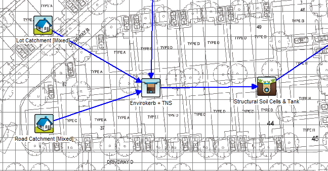
| In the model | Standard node | What it accounts for |
|---|---|---|
| Lot Catchment [Mixed] | Urban source node | Roofs, driveways and private hardstand draining to that node |
| Road Catchment [Mixed] | Urban source node | The road pavement and kerb-line area draining to that node |
| EnviroKerb + TNS™ | Media filtration node | The kerb units and the storage held at source – both catchments drain into it. |
| Structural Soil Cells & Tank | Bioretention filter node | The media profile, extended detention and the vegetated surface above it |
| Sub-soil relief | Outflow link | The saturated case only – flow leaving at seepage rates once storage is satisfied. |
The model uses two source nodes, two system nodes and ordinary drainage links. Both system nodes are standard MUSIC node types – a media filtration node and a bioretention filter node – with parameters set per project against the relevant local guideline.
The subsoil component of the TNS™ is often mis-read as a conveyance pipe. It is a subsoil relief drain under AS/NZS 3500.3, not a minor or major conveyance outfall in the drainage-manual sense.
The line only relieves excess soil water once the TNS™ storage is exhausted. It is a relief mechanism for the saturated case – not a primary conveyance path that carries the storm.
Any relief flow leaves at seepage rates, once the storage and substrate are saturated. It is excess soil water being relieved, not stormwater being conveyed.
Road authorities themselves daylight the same class of relief drain onto batters and footpath flow paths, which makes the classification well-trodden.
Why it matters for approval: framed as a relief drain and not an outfall, the TNS™ does not require a lawful point of discharge demonstration in the conveyance sense. We provide the classification basis and supporting detail as part of the specification package.
| Reference | Applies to |
|---|---|
| MUSIC | Modelling of each node, using standard in-built nodes |
| Australian Rainfall and Runoff (ARR) | Hydrologic and hydraulic design and assessment of the system – the national standard, applying in every state. |
| Local drainage manual | Where a state or council adds its own requirements on top – QUDM in Queensland, the equivalent manual elsewhere. |
| AS/NZS 3500.3 | Classification of the sub-soil relief drain |
| Class D load rating | The kerb-line tray in the traffickable zone – fully trafficable |
| AustRoads | Limits on standing water in traffickable zones during an event |
| AS 4419 | Soils for landscaping and garden use – the filter media and planting soil |
| AS 2303 | Tree stock for landscape use – what arrives on site |
| AS 5334 | Climate change adaptation for settlements and infrastructure, where climate risk is being addressed. |
The assessment approach is national, because ARR applies in every state and the node arrangement is modelled the same way wherever the site is. A position agreed with one authority carries to the next without being re-argued from scratch. Where a council or state manual sets additional modelling or classification requirements, those are picked up in the pre-lodgement discussion.
The package holds everything an assessing engineer needs to check the system, sized to the actual site and not to a product catalogue.
The node arrangement modelled for retention and relief behaviour, with the standard node parameters used for each element set out in full.
The relief-drain position is set out with supporting detail, so that the subsoil line is assessed as a relief drain.
Runoff calculated per node, setting the storage volume and the number of ETI and EnviroKerb units.
Node details for the variant selected, and the kerb-line arrangement for the run.
The tiered response framework, the equipment required, and what the council already owns to service it. The full maintenance case →
Servicing cost set against the centralised basin the system displaces, prepared for the project.
Where quality obligations sit. Where a development also carries stormwater quality obligations, those are met by separate, appropriately certified measures. The TNS™ is assessed on retention and storage – it is not offered as a substitute for a certified quality device where one is required.
We send the specification sheet, standard drawings and ARR-referenced hydrologic and hydraulic parameters by email, with the MUSIC node parameters if you are modelling.
The maintenance technical paper has its own request form on the maintenance page.
Send us the catchment and the guideline you're assessing against. We'll provide the model, the node parameters and the classification basis – and talk them through with your assessing engineer.